.png)

Aspen Acres Fire Grows to 99,820 Acres as Crews Contain Spot Fire Near Rye
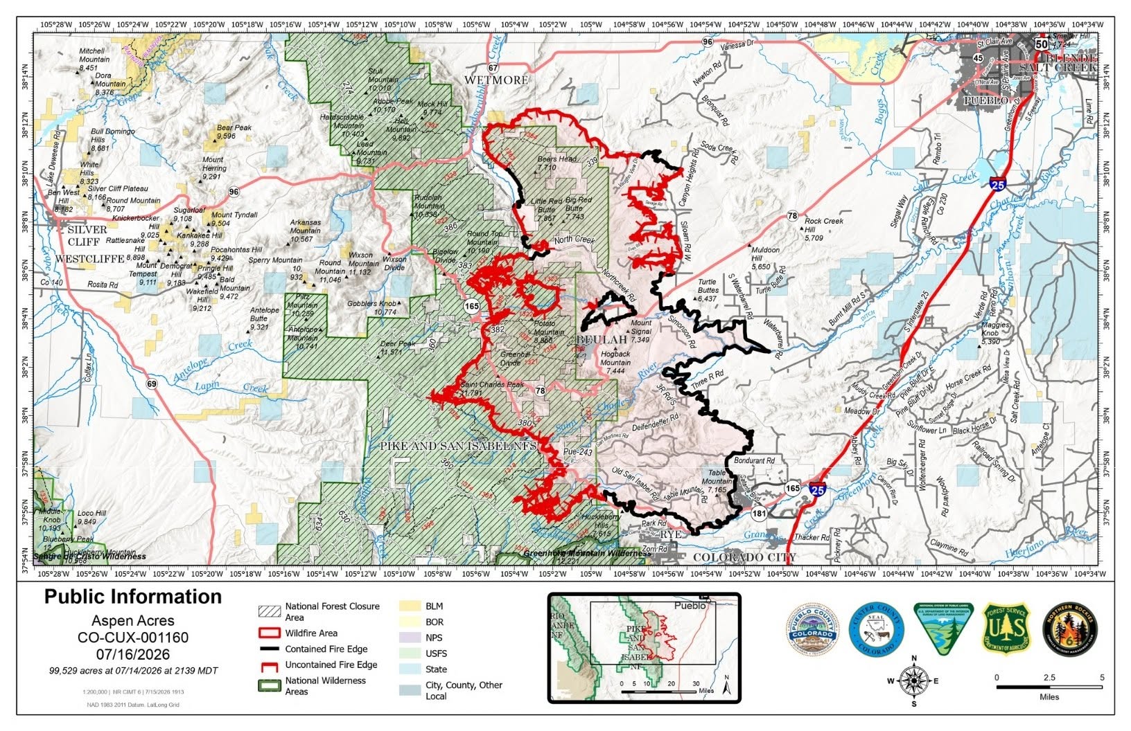
Description: The Aspen Acres Fire reached 99,820 acres and remains 36% contained on July 16. Crews stopped a spot fire west of Rye as evacuations remain in effect...
Aspen Acres Fire Update for July 16, 2026
Location: 10 Miles NW of Rye, CO in Custer and Pueblo Counties
Start Date: Reported 06/29/2026 around 6:00 a.m.
Cause: Human, Under Investigation Size: 99,820 acres
Containment: 36% Total Personnel: 1,724
COMMUNITY MEETING
A community meeting will be held in Gardner at the Raymond Aguirre Community Center on Friday, July 17, at 7 p.m. The address is 28 County Road 632 in Gardner.
KEY MESSAGE
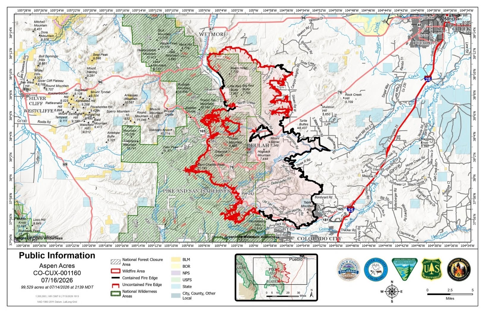
Fire activity increased on the southwest side of the fire on Wednesday afternoon as temperatures rose and winds increased. A spot fire crossed the first of two defensive lines that were still under construction on the south side of the “chicken foot,” to the west of Rye. Swift and aggressive response by firefighters on the ground, dozers, and firefighting aircraft dropping water and retardant was successful in catching the spot fire. Drones with infrared capabilities were deployed on Wednesday night to monitor for hot spots in the area and firefighters responded. Crews, machinery, and aircraft are all deployed in that area again on Thursday as fire activity is expected to increase in the afternoon.
Conditions such as these are the reason why evacuation orders remain in effect for Rye and other communities on the west side of the fire. Huge progress has been made, but the wildfire is still uncontained with potential threat to life and property. Firefighters continue working both day and night shifts, striving towards additional containment.
Near San Isabel, crews conducted strategic firing operations to reduce fuels between the constructed defensive lines and the wildfire. Operations on Wednesday were successful and are planned to continue on Thursday. Crews are gradually connecting constructed dozer lines and hand lines. Structure protection work is ongoing.
Fire activity at Saint Charles Peak was moderate again on Wednesday, as firefighters continued pushing to construct primary and secondary fireline. Crews and heavy equipment are clearing vegetation along Forest Roads 360 and 369. Reconnaissance flights are routinely monitoring for heat throughout the fire area.
Methodical search continues for smoldering hot spots on the northeast side of the fire. Crews are still working in this area, running chainsaws to remove brush and lower tree limbs, working with hand tools, using engines, pumps, and water to cool smoldering hot spots. Watch for firefighters working in the areas of Savage Road, Even Road, Ponderosa Pine Drive, San Isabel Drive, Siloam Road, and others in this area. Please drive carefully, yield to firefighting traffic, and give room to crews working alongside roads and communities.
WEATHER AND FIRE BEHAVIOR
Moisture is slowly increasing, forming clouds, and bringing showers to the west of the fire area. Slightly cooler temperatures are forecast for Thursday, but conditions remain hot and dry with east winds. A chance of afternoon thunderstorms persists. As temperatures and winds increase in the afternoon, fire activity is expected to increase on the west side of the fire, posing threats similar to fire behavior observed on Thursday. Fuels remain extremely receptive to fire.
AREA CLOSURE
There is an Aspen Acres Fire Area Closure for the San Carlos Ranger District. Visit: https://www.fs.usda.gov/.../aspen-acres-fire-area-closure . Please monitor land managing agencies for other fire restrictions. The National Forest Lands are closed and are also in evacuation status.
There is a Temporary Flight Restriction (TFR) in place above the fire area. Flying any aircraft within the TFR is prohibited. This includes the use of drones, or unmanned aerial systems.
EVACUATIONS
All evacuations are managed by the respective county sheriffs. Monitor county social media pages or call county contacts for more information.
An Awareness status is in place for Fremont County, encouraging residents to stay informed, monitor official updates, and remain prepared.
In Pueblo County, evacuation status has been lifted for the north and northeastern portions of the Aspen Acres Fire perimeter. Residents south of Highway 96 and North of Highway 78 are allowed to return to their homes. All residents will remain in pre-evacuation status and must be prepared to leave should conditions change. The fire remains active near North Muddy Creek, with potential to advance toward Rye. Thus, evacuation status remains on the south side of the fire, with Colorado City remaining in pre-evacuation status. For Pueblo County evacuation information, call the Joint Information Center (JIC) at 719-583-4640; information about the Disaster Assistance Center (DAC) is also available.
Wetmore and Greenwood residents may return home; the area remains in pre-evacuation status. Other areas of Custer County affected by the fire remain in pre-evacuation and evacuation status. For Custer County re-entry questions or specific evacuation status, call 719-467-0271.
Huerfano County Sheriff's Office evacuated all areas within the National Forest to the East of where Williams Creek crosses into the National Forest and then following Williams Creek North to where Williams Creek intersects with CR 630 and following CR 630 generally north to where CR 630 intersects with CR 636 and continuing to follow CR 630 west to where it intersects with CR 634 (Gardner Road) and then running due North to the County Line. Southern and Eastern boundaries of the evacuation zone are the US Forest Service boundary and the Northern boundary is the County Line. For further information, call 719-738-1044 to reach Huerfano County dispatch.
AIR QUALITY
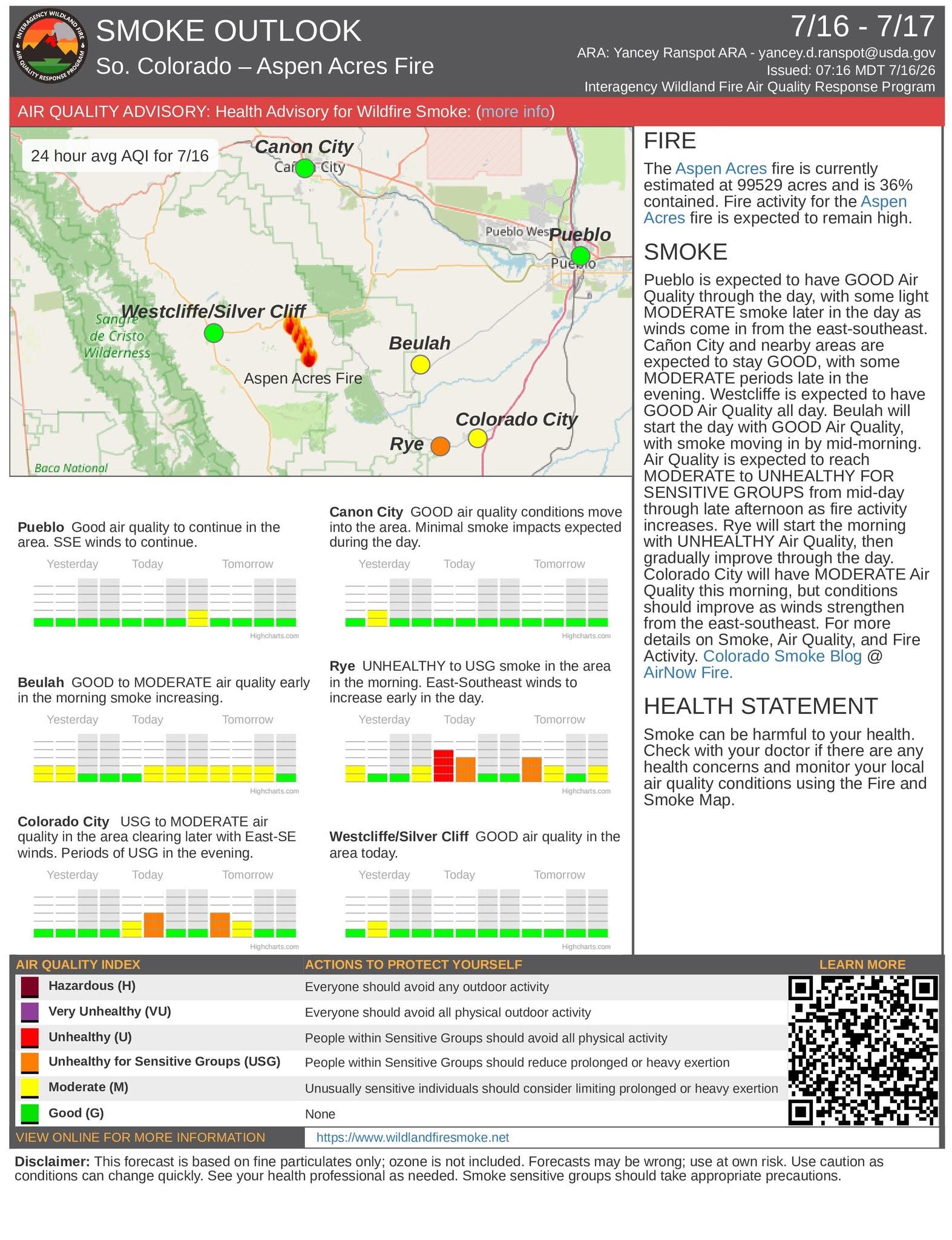
An Air Resource Advisor is assigned to the incident and assessing where communities may be impacted by smoke. To get daily air quality information, visit https://fire.airnow.gov/
OFFICIAL WEBSITES
The public and members of the media should monitor the following official websites:
Follow Pueblo County Sheriff's Office Facebook at Pueblo County Sheriff's Office and X: @PuebloCountySO https://x.com/PuebloCountySO.
Follow Custer County Sheriff’s Office Facebook at https://www.facebook.com/CCSOAdmin.

Image Gallery