

NWS Office of Pueblo: Drought Info Statement - June 16, 2022
Description: The National Weather Service Office of Pueblo Released the following Drought Information Statement on June 16, 2022.
DROUGHT INFORMATION STATEMENT
National Weather Service National Weather Service Pueblo Co
809 AM MDT Thu Jun 16 2022
...Drought Deepens across South Central Colorado with some Improvement
across Southeast Colorado...
SYNOPSIS...
The first half of May started where April left off, with very warm,
windy and dry weather bringing critical and extreme fire weather
conditions to much of south central and southeast Colorado. May,
however, ended cool and wet, especially across portions of south
central and southeast Colorado, when an unseasonably strong weather
system brought 10 to 30 inches of wet, heavy snowfall and very
beneficial precipitation to the Pikes Peak region, the southeast
mountains and the Upper Arkansas River Valley, as well as portions of
the I-25 Corridor and southeast plains. The relatively cool and stormy
pattern continued into the first part of June across southeast Colorado,
where strong thunderstorms brought heavy rainfall to portions of the
southeast plains. Unfortunately, this beneficial moisture did not
make west of the Front Range, with much of the western portions of the
state, especially southwestern Colorado, remaining hot and dry
through the end of May and into June.
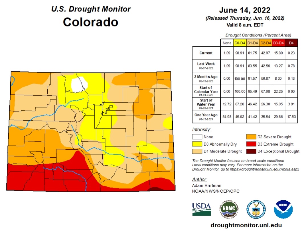
With that said, the latest US Drought Monitor issued Thursday, June 16th,
2022, has expanded Extreme Drought (D3) conditions across south central
Colorado and now includes all of Mineral, Rio Grande and Conejos
Counties, as well as southwestern into northeastern portions of
Saguache County, and most of Alamosa and Costilla Counties. Extreme
drought (D3) conditions are also depicted across extreme southern and
southeastern Las Animas County and into southern Baca County, where
only a silver of Exceptional Drought (D4) conditions remains across
far southwestern Baca County.
Severe drought (D2) conditions are now indicated across central Las
Animas County into northern Baca County, extreme western Otero County,
extreme southeastern Crowley County, most of Bent County, as well as
southwestern portions and extreme eastern portions of Prowers County
into extreme eastern portions of Kiowa County. Severe drought (D2)
conditions are also indicated across northwestern and extreme eastern
portions of Saguache County, extreme northeastern Alamosa County,
northeastern Costilla County and extreme western portions of Custer
and Huerfano Counties.
Moderate drought (D1) conditions are now depicted across Lake County,
most of Chaffee and Fremont Counties, eastern Custer and Huerfano
Counties into north central Las Animas County. Moderate drought (D1)
conditions are also indicated across the eastern 2/3rds of El Paso
County, extreme northeastern and southeastern Pueblo County, the rest
of Crowley and Otero Counties, northeastern Bent County, the rest of
Prowers County and north central Kiowa County.
Abnormally dry (D0) conditions are now indicated across east central
Chaffee County, Teller County, western El Paso County, extreme eastern
Fremont County, most of Pueblo County and western portions of Kiowa
County.
More information about drought classification can be found at:
droughtmonitor.unl.edu/About/AbouttheData/DroughtClassification.aspx
DROUGHT IMPACTS...
FIRE DANGER...
Very dry and windy weather through out April and the first half of May
brought high to extreme fire danger to most of south central and southeast
Colorado. Several wildfire starts across south central and southeast
Colorado prompted strict fire bans and restrictions across most of
south central and southeast Colorado into the month of May. However,
with the beneficial moisture received across portions of south
central and southeast Colorado over the past month, some counties
across the plains have loosened fire restrictions.
The latest information on fire bans and restrictions across the area
can be found at: www.coemergency.com/p/fire-bans-danger.html
AGRICULTURAL...
The USDA`s "Colorado Crop Progress" report for the week ending June
12th, 2022 indicated 21 percent of topsoil moisture and 37 percent of
subsoil moisture across the state being reported as very short, as
compared to 32 percent of topsoil moisture and 48 percent of subsoil
moisture reported as very short the previous week. CPC soil moisture
products as well as the shorter term (1 week, 1 month) Evaporative
Demand Drought Index (EDDI) data indicates improving soil moisture
conditions across southeast Colorado, with drying conditions noted
across south central and southwestern Colorado.
HYDROLOGIC...
NRCS data indicated the statewide snowpack on June 1st was at 94
percent of median, as compared to 67 percent of median at this time
last year. Statewide snowpack was bolstered by a late season storm
which brought late season snow to the Arkansas and northern basins.
This storm, however, brought very little precipitation to the southern
basins, especially the southwestern mountains, where snowpack has
already melted out.
In the Arkansas basin, June 1st snowpack came in at 100 percent of
median, as compared to the 81 percent of median snowpack at this time
last year. June 1st snowpack improved due in part to 135 percent of
median precipitation recorded through the month of May, which brings
water-year-to-date precipitation across the Arkansas basin up to 92
percent of median.
In the Rio Grande basin, June 1st snowpack came in at 0 percent of
median, as compared to 30 percent of median at this time last year.
May precipitation across the Rio Grande basin was 75 percent of
median bringing water-year-to-date precipitation to 81 percent of
median.
NRCS data also indicated statewide water storage was at 79 percent of
median overall at the end of May, as compared to the 84 percent of
median storage available at this time last year.
In the Arkansas Basin, water storage at the end of May came in at 92
percent of median overall, as compared to the 92 percent of median
storage available at this same time last year.
In the Rio Grande Basin, water storage at the end of May came in at
83 percent of median overall, as compared to the 84 percent of median
storage available at this time last year.
June 1st streamflow forecasts in the Arkansas Basin range from 31
percent of median at Purgatoire River near Trinidad to 79 percent of
median at the Arkansas River at Salida.
June 1st streamflow forecasts in the Rio Grande Basin range from 16
percent of median at Sangre de Cristo Creek to 48 percent of median
at the San Antonio River at Ortiz.
CLIMATE SUMMARY...
The average temperature in Alamosa for the past month of May was 53.3
degrees. This is 1.6 degrees above normal and makes May of 2022 tied
as the 14th warmest May on record. Alamosa recorded 0.39 inches of
precipitation through the month of May, which is 0.21 inches below
normal. Alamosa also tallied 0.2 inches of snow through out the month
of May.
The average temperature for the Spring of 2022 in Alamosa was 43.0
degrees, which is 0.1 inches below normal. Alamosa recorded 1.27
inches of precipitation through the Spring of 2022, which is 0.41
inches below normal. Alamosa 7.4 inches of snow through the Spring,
which brings the 2021-2022 seasonal snowfall total in Alamosa up to
19.5 inches.
The average temperature in Colorado Springs for the past month of
May was 59.1 degrees. This is 2.0 degrees above normal and makes
May of 2022 the 11th warmest May on record. Colorado Springs recorded
2.02 inches of precipitation through the month of May, which is 0.03
inches above normal. Colorado Springs recorded 10.3 inches of snow
through the month of May. This is 9.7 inches above normal and makes
May of 2022 the 5th snowiest May on record.
The average temperature for the Spring of 2022 in Colorado Springs
was 50.6 degrees. This is 2.0 inches above normal and makes the
Springs of 2022 the 5th warmest Spring on record. Colorado Springs
recorded 2.78 inches of precipitation through the Spring of 2022,
which is 1.45 inches below normal. Alamosa 18.2 inches of snow
through the Spring, which is 6.4 inches above normal. This brings the
2021-2022 seasonal snowfall total in Colorado Springs up to 33.4
inches, which is 0.9 inches above normal.
The average temperature in Pueblo for the past month of May was 61.2
degrees, which is 0.2 degrees below normal. Pueblo recorded 2.41 inches
of precipitation through the month of May, which is 0.84 inches above
normal. Pueblo recorded 3.2 inches of snow through the month of May.
This is 3.2 inches above normal and makes May of 2022 the 7th snowiest
May on record.
The average temperature for the Spring of 2022 in Pueblo was 51.8
degrees, which is 0.4 inches below normal. Pueblo recorded 4.25 inches
of precipitation through the Spring of 2022, which is 0.29 inches
above normal. Pueblo 12.1 inches of snow through the Spring, which
4.2 inches above normal. This brings the 2021-2022 seasonal snowfall
total in Pueblo up to 25.8 inches.
Here are a few other statistics for select south central and
southeast Colorado locations, indicating observed precipitation totals
and departure from normal for the past month, past 3 months, past 6
months and past 365 days:
| ................... | PAST |
PAST 3 |
PAST 6 |
PAST 365 |
| ................... | MONTH |
MONTHS |
MONTHS |
DAYS |
| ................... | TOTAL/DEP |
TOTAL/DEP |
TOTAL/DEP |
TOTAL/DEP |
| .................. | INCHES |
INCHES |
INCHES |
INCHES |
| ALS Airport | 0.39/-0.21 | 1.28/-0.40 | 2.01/-0.62 | 4.87/-2.52 |
| COS Airport |
2.02/+0.03 |
2.78/-1.45 |
3.63/-1.44 |
10.48/-5.43 |
| PUB Airport |
2.41/+0.84 |
4.25/+0.29 |
5.48/+0.62 |
13.46/+1.44 |
| Lamar |
1.79/-0.14 |
2.39/-1.72 |
3.67/-1.65 |
11.49/-4.70 |
| Campo 7S |
1.10/-0.72 |
1.28/-2.71 |
1.47/-3.70 |
5.86/-10.90 |
| Walsh 1W |
1.90/-0.22 |
2.50/-2.33 |
3.73/-2.33 |
11.96/-7.57 |
| Kim 15NNE |
1.43/-0.22 |
3.48/-1.07 |
4.95/-1.41 |
14.62/-2.07 |
| FlorissantFB |
2.65/+1.06 |
4.11/+0.48 |
5.38/+0.45 |
15.27/+0.30 |
| Canon City |
1.57/+0.01 |
2.85/-1.51 |
4.85/-1.09 |
11.92/-1.80 |
| Rye 1SW |
2.97/+0.58 |
8.31/+0.29 |
12.46/+0.78 |
23.39/-1.98 |
| Westcliffe |
2.37/+0.96 |
4.69/+0.66 |
6.85/+1.23 |
14.14/+0.55 |
| Trinidad |
1.19/-0.33 |
2.62/-1.37 |
3.25/-2.29 |
11.86/-1.01 |
| Crestone 2SE |
1.21/+0.06 |
2.55/-0.66 |
3.79/-0.98 |
10.16/-2.27 |
| Del Norte 2E |
0.12/-0.68 |
1.15/-1.16 |
2.28/-1.29 |
6.38/-3.30 |
| Buena Vista 2S |
2.28/+1.66 |
4.17/+1.36 |
5.39/+1.38 |
11.90/+1.97 |
| Climax |
2.51/+0.54 |
7.56/+0.31 |
10.70/-2.99 |
24.43/-0.80 |
PRECIPITATION/TEMPERATURE OUTLOOK...
The Climate Prediction Center (CPC) outlook for the next week
indicates better chances of at to above normal temperatures and
precipitation across south central and southeast Colorado, with
the better chances of above normal precipitation along and west
of the Continental Divide. The outlook for the rest of June, July
and August still indicates better chances for above normal
temperatures and below normal precipitation across all of south
central and southeast Colorado.
NEXT ISSUANCE DATE...
This product will be updated by Thursday July 14th, 2022, or sooner
if necessary, in response to significant changes in conditions.
RELATED WEB SITES...
Additional information on current drought conditions may be found at:
www.droughtmonitor.unl.edu
www.weather.gov/pub/
ACKNOWLEDGMENTS...
The drought monitor is a multi-agency effort involving The National
Drought Mitigation Center, NOAA`s National Weather Service, The USDA
and state and regional center climatologists. Information for this
statement has been gathered from NWS and FAA observation sites,
Colorado Cooperative Extension Services, The NRCS, USDA, USACE and
USGS.
QUESTIONS OR COMMENTS...
If you have any questions or comments about this drought information
statement, please contact:
National Weather Service Forecast Office
3 Eaton Way
Pueblo, Colorado 81007
Phone: 719-948-9429
or email to: nws.pueblo@noaa.gov

Image Gallery

